On April 2, after returning to Campo, I drove to Julian. Lodging at Julian Lodge - $74 - no hot tub; continental breakfast not served until 7:30; very quiet on spring weeknights due to 25 mph speed limit in Julian. Margarita's across the street serves inexpensive hot breakfast at 7:00 and dinner as well, though not as late as Rong Branch, which serves dinner until 9:00 - about $25 for steak dinner with Julian Apple Pie desert. Avoid Julian on fall weekends! But it is very slow on foggy April weeknights.
Apr 3 - 24 mi - Hwy 78(78.1-2252) to (66-4200) & back - lodging at Julian Lodge.
I had hoped to get to 64.3 but was worried about a blister and ran out of time. The blister collapsed on its own the next day, though.
The tick brush (my generic term for chaparral overgrowing the trail so that one can't get by without giving either the east side or west side team, or both, a chance to latch on) is getting real healthy around mile 66. Fleece pants seem to fool ticks into thinking they are burrowing into one's fur, so they amuse themselves trying that instead of prospecting for a better port of entry, allowing one time to pick them off.
At Scissors, the two gallons by the gate in the morning of April 3 had miraculously multiplied to half a dozen or more by night, so the water supply north through the San Felipe hills should be easy for a while.
I thought about my earlier promise at the border monument, and decided to plant some water each day. I hope that hikers finding those bottles that don't really need them, will leave them for those coming later that will. And I hope that the person who finishes a bottle takes the empty on to the next recycling opportunity.
Apr 4 - 26 mi - Hwy 78(78.1-2252) to (90.9-3485) & back - southern San Felipe.
Lodging at Apple Tree Inn, halfway between Julian and Santa Ysabel, $63, no hot tub, no breakfast, and noisier since the speed limit on the highway is 55.
Apr 5 - 22 mi - Hwy S22(102.0-3445) to (90.9-3485) & back - northern San Felipe - lodging at Apple Tree Inn.
Apr 6 - 20 mi - Hwy S22(102.0-3445) to (112.4-2930) & back.
There is no problem following the trail from Barrel Spring to Warner Springs; the guidebook main text suggests a compass would be helpful, but if you read the 2000 update, they note that the route is much improved.
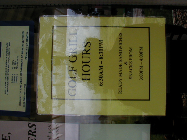
The Warner Springs Golf Grill seems blissfully unaware of its significance as the closest thing to a full-time full-service restaurant on the PCNST for a few hundred miles. In fact everything about Warner Springs Ranch resort suggests they really don't need non-members. Kit Carson could bathe in the springs, and the Butterfield Stage passengers, but you can't.
A long-standing mystery was cleared up by a sign about the California Riding and Hiking Trail . I'd first seen a couple of isolated trail markers for the CRHT in 1971 on Mt Tamalpais, and wondered what their significance was. I wrote to the California State Parks in Sacramento and received a one-page state map with the general route of various sections indicated with a very broad brush stroke, representing the status of the project at some earlier time. Evidently it had been abandoned already by then as a state project, superseded in some places by suburbia and in others perhaps by the PCNST. But I learned from the sign at Warner Springs that some enthusiastic volunteers in San Diego County are keeping parts of it alive - the Forest Service and USGS maps indicate a section running from near Descanso into San Felipe Valley. Anyway you can follow a newly- renovated section from the PCNST about a mile over to near the Golf Grill as an alternative to walking along Hwy 79 (but then you miss the water at the CDF fire station).
Page 67 of the guidebook complains about the trail alignment through the San Felipe hills, and this may indeed be dangerous in May. In early April, though, I enjoyed the sun (despite the cold wind) and observed the opposite Volcan Mountain shrouded in cold windy fog afternoons, nights, and mornings - and snow from time to time. The Forest Service evidently didn't want to go to court to get an alignment on Volcan from numerous private landowners, but later efforts by Volcan Mountain Preserve Foundation may yet provide a means to hike that way.
On those "amazingly long gentle grades" one has plenty of time to think about something, and I considered how Julian might try to improve its spring weeknight economy. As far as I am concerned, the PCNST could have followed the ridge west of Chariot Canyon down to Julian, past the Post Office and down Main Street, then out along Volcan Mountain down over the San Felipe to the S-22 pass above Montezuma Valley, then north through the Los Coyotes reservation to eventually join up with the current trail north of Warner Springs.
What's done is done, though, but I wonder if the town parents of Julian's chamber of commerce should consider creating a trail along part of that alignment in order to make a nice long loop that could be hiked in the spring with a little help. I'm thinking of something like the Yosemite High Sierra Camps loop, which is only 40 miles, that is extremely popular - reservations by lottery in December the year before the July-September season - albeit never yet profitable for the concessioner. Nothing like that will ever be allowed again in wilderness areas - the Forest Service apparently was quite hard-nosed even about unconforming uses at Boulder Oaks store and Mission Creek hostel - but the abundance of private land around the trail in San Diego County could be thought of as an advantage in this respect. If tent cabin camps were set up every 15 miles or so during the spring hiking season - with trucked in water, propane, and porta-potties - through hikers could go through Julian or San Felipe as they preferred, and the Julian Chamber of Commerce could advertise loop hikes and rides around an 80-mile or so loop, from at least around mile 61 to mile 102. The added traffic and water sources would remove some of the danger of the San Felipe route in hot weather, and allow through hikers to carry less. There is a lot of private residential land around Julian, and a route there would probably involve at least a few miles of pavement.
Wilderness is where you find it, and how you feel it. The San Felipe seems very remote, despite the roars from the jets above and the trucks below on S-2, and some people would rather keep it that way I'm sure. However there is an awful lot of statutory lonely wilderness further north for through hikers, and I for one wouldn't mind exploiting some of the private land adjacent to this part of the trail. I think the local Julian merchants, who would most benefit, would be the ones to promote this to their neighbors, rather than the Forest Service.
Apr 7 - on my way home, a few yards of map E10 at hwy 138 (516.0-3040), and a look at the Gorman Post Road.
Links: